Tumut Plains.
TUMUT PLAINS RUN
"BEEN"
"Run No. 154"
Property Details
Acres = Estimated area, (20.000 acres) twenty thousand acres.
Estimated grazing capabilities, nine hundred cattle, or four thousand sheep. Bounded on the north by Goobaragandra Creek for eight miles; on the west by the Tumut River to where the Blowering Mountain comes into the river; on the south by Blowering Mountain, which separates my run from Whitty's; on the east by the Boogong Mountains. (Ref- The Sydney Morning Herald (NSW : 1842-1954) Monday 16 October 1848).
Obtaining title to the land in 1839 Mr. Rose then sold to George and William Shelley, who had been at Bombowlee for 10 years.
This seems to have been the first property sale. This 1280 acres is Block No. 1 on the County of Buccleugh land map; No. 2 being the
block next to it taken up in the name of George Shelley’s wife Amelia. Mr. George Shelley had married Miss Amelia M. Waddy at
Parramatta on September 1st 1835 and brought his bride to Bombowlee, Tumut, where he had been the first land holder. Mrs. Thomas
McAlister of Darbalara (mentioned earlier) had the house in readiness when the bride and groom arrived - these were the first two
white women in Tumut.
George Shelley sold out his Bombowlee property to his eldest brother William Shelley. At the death of William Shelley in 1845 George
Shelley became the sole owner of Tumut Plains. The first house the Shelleys occupied was near the Goobragandra River. This house was
unusual for its time in that it was built partly of brick (said to have been ballast in a ship) and lathe and plaster. Fruit trees
still mark the spot - quinces, plums and mulberrys
Index to Squatters and Graziers - Date Surname First Name Station Description Citation Remarks
10 July 1839 Kelley W & G Tumut Plains Henry Bingham Esq County of Murray NRS 906 [X812]; Reel 2748-2749, Page 1 Superintendent: John Rogers.
10 July 1839 Shelley W & G Tumut Plains Henry Bingham Esq County of Murray NRS 906 [X812]; Reel 2748-2749, Page 1 Superintendent: John Rogers. - (Ref- http://srwww.records.nsw.gov.au/indexsearch/searchhits_nocopy.aspx?table=Index to Squatters and Graziers&id=70&frm=1&query=Station:tumut plains)
TUMUT.-The deaths occurred of well known and highly respected local identity,
Mr. William Regent, for many years farmer, at Tumut Plains, aged 69, - (Ref- The Sydney Morning Herald (NSW : 1842 - 1954)(about) Previous issue Monday 8 September 1924).
Mr Jonathan Regent, a farmer, resident at Tumut Plains, has been killed by lightning, as well as the horse upon which he was at the time riding.- (Ref- The Sydney Morning Herald (NSW : 1842 - 1954) Saturday 15 February 1862).
A MAN AND HORSF STRUCK DEAD BY LIGHTNING - On Wednesday last Mr Jonathan Regest, a farmer, residing on Tumut Plains, left home in the morning to look after some cattle, intimating to his wife his intention of being back in the evening. Evening came, however, but not poor Regent, and be being a man of regular and punctual habits, his wife and family became alarmed at his absence.
On the following morning the neighbours instituted a searoh, which terminated successfully about three o'clook on Friday afternoon, when Regent and his horse were both found dead about six miles from his residence, under a tree which had been struck by lightning. It is therefore conjeotured that he had taken shelter under this tree during the storm that prevailed on Wednesday afternoon, and had been struck by the lightning.
Death, both to himself and his horse, must have been instantaneous there could have been no struggle, as one of Regent's feet still remained in the stirrup. His remains were brought home and interred in the Church of England cemetery - (Ref- Wynyard Times, February 4. - (Ref- The Maitland Mercury & Hunter River General Advertiser (NSW : 1843 - 1893)Tuesday 11 February 1862).
PORTION No.s Portion No.1 - Parish of Blowering - County of Buccleuch.
In 1829 just 4 years after Hume & Hovell passed through the area just south of his run. James Hannibel ROSE was on the ").Tumut Plains Run"
In the same year 1829 mention is made of Mr John Stuckey's property being situated further down the Murrumbdgee River from the Warby Run. So that made a small hand full of permanent people living in the area. Including
Mr George Shelley Name of run, "Bombowlee"
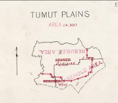 Tumut Plains Early Map
"EMPLOYEES" and or "SUB DIVISION" owners.
Sometime in 1844
Mr Augustus LeFevre
arrived at "Tumut Plains" to work on the property.
In 1880 Mr George Johnson, 1st
is listed as working on "Tumut Plains".
In 1843 Mr John ATKINSON purchased "Ashfield Farm" at Tumut Plains, NSW
William John Smiles was on a property in Tumut Plains
Chinese In the Kiandra - Tumut Plains - Tumut - Blowering areas.
Mr John HALLORAN
Mr Killalea
Sturt Families
ADAMS, William farmer Tumut Plains Tumut - (Ref- Greville's 1872 Post Office Directory)
GRAVES Hedley farmer Tumut Plains Tumut - (Ref- Greville's 1872 Post Office Directory)
GREEN George farmer Tumut Plains Tumut - (Ref- Greville's 1872 Post Office Directory)
HOWE James farmer Tumut Plains Tumut - (Ref- Greville's 1872 Post Office Directory)
HOWE John carrier Tumut Plains Tumut - (Ref- Greville's 1872 Post Office Directory)
IBBOTSON George farmer Tumut Plains Tumut - (Ref- Greville's 1872 Post Office Directory)
NAUGHTON Hugh farmer Tumut Plains Tumut - (Ref- Greville's 1872 Post Office Directory)
REGENT, Jonathan farmer Tumut Plains Tumut - (Ref- Greville's 1872 Post Office Directory)
STURT, George farmer Tumut Plains Tumut - (Ref- Greville's 1872 Post Office Directory)
VICKERY Edward farmer Tumut Plains Tumut - (Ref- Greville's 1872 Post Office Directory)
HOWE John carpenter Tumut Plains Tumut - (Ref- Greville's 1872 Post Office Directory)
This report is submitted in good faith. All endeavours have been made to make all entries authentic and correct. For any corrections and additional valuable information, maps and photos you may have please contact John
To Home page